I was standing at the corner of SR 305 and Winslow Way last month, watching the morning ferry crowd disperse into downtown Winslow, when something clicked. The steady hum of traffic mixed with the distant ferry horn, and I could smell that familiar blend of saltwater and Douglas fir that makes Bainbridge feel like home. But what really got my attention was imagining this exact spot transformed into something much more welcoming, a proper gateway that says “welcome to the trails” instead of just “welcome to more pavement.”
That’s exactly what’s happening here. A community group is working on creating what they’re calling “Citizen Park” right at this intersection, and honestly, the timing couldn’t be better. This little patch of land is destined to become the front door to one of the most ambitious trail projects I’ve ever seen in Kitsap County.
The Sound to Olympics Trail: Connecting Two Worlds
The Sound to Olympics Trail, or STO, as those of us following its progress like to call it, isn’t just another local path. Picture this: you could theoretically start your ride on Seattle’s Burke-Gilman Trail, catch either the Winslow or Kingston ferry (depending on where you’re headed), and continue pedaling all the way to the Olympic Discovery Trail beyond the Hood Canal Bridge. The morning mist would follow you from Puget Sound clear through old-growth forests to the Olympic Peninsula.
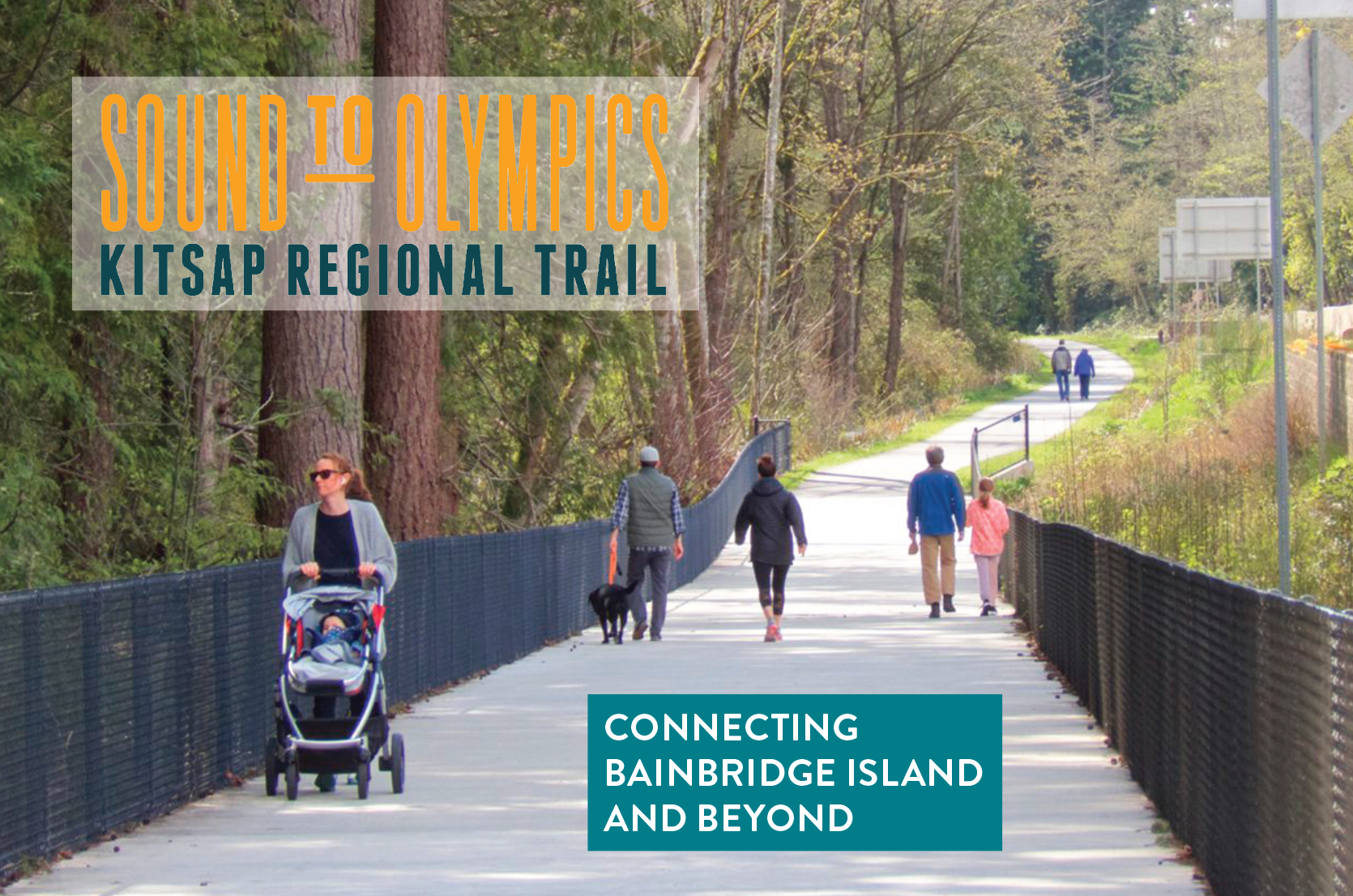
AllTrails – Sound to Olympics Trail, Bainbridge Island
Credit: AllTrails, Sound to Olympics Trail
I think what excites me most about the STO is how it’s designed with real families in mind. When the North Kitsap Trails Association developed the String of Pearls Trail Plan, they made sure this wasn’t going to be another narrow, root-filled singletrack that intimidates parents with strollers. The plan calls for a paved, accessible facility where wheelchairs, walkers, and those leisurely Sunday cyclists can all share the same space without anyone feeling rushed or left out.
The sound of gravel crunching under bike tires along existing trail sections gives you a taste of what’s coming, but the STO promises something smoother, more like the soft hum of wheels on pavement that you hear along Seattle’s waterfront paths.
What’s Already Built (And It’s Beautiful)
Here’s the thing that surprised me most when I first walked the completed section: they’ve already built 800 feet of this vision, including a genuinely stunning bridge over the Winslow Ravine near the Vineyard Lane development. The morning light filtering through the bridge’s design creates these shifting shadow patterns on the path below, and you can hear the gentle rustle of leaves from the ravine’s canopy even when you’re crossing above it.
Standing on that bridge, breathing in the earthy smell of moss and cedar from below, you get a real sense of what the entire STO could feel like. It’s not just functional, it’s actually beautiful in a way that makes you want to slow down and notice where you are.
Credit: Bainbridge Island Parks & Trails Foundation
North Kitsap Trails Association (NKTA), along with the Bainbridge Non-Motorized Transportation Advisory Committee, Squeaky Wheels, and Go Bainbridge, are all pushing to extend this magic, particularly through that first crucial mile of SR 305 from the Washington State Ferries terminal. Anyone who’s tried to walk or bike that stretch knows it’s not exactly welcoming right now, the whoosh of cars passing a few feet away makes conversation impossible.
The Seattle Connection That Changes Everything
What really gets my pulse up about this project is how it connects with Seattle’s waterfront reconstruction. The Seattle Department of Transportation is building a shared-use path as part of their massive waterfront overhaul, and that path will link directly with the existing trails in Myrtle Edwards Park. Imagine stepping off the ferry in Seattle and having a continuous, car-free path stretching from the Olympics to Elliott Bay, the salt air following you the entire way.
I’ve walked parts of the new Seattle waterfront path during construction, and the scale is impressive. The concrete still smells fresh in some sections, and you can hear the rhythmic sound of construction equipment working to create something that will outlast all of us. When it’s complete, the connection between Seattle’s waterfront and our Kitsap trails will feel seamless in a way I’ve never experienced around here.
Citizen Park: More Than Just a Name
Back to that corner where this all started in my mind, the future Citizen Park. The working name might change (and they’re actively seeking community input on what to call it), but the vision is solid. This isn’t just going to be another small-town park with a bench and some landscaping. It’s being designed as a true gateway that celebrates the natural beauty of the Winslow Ravine, which contains some of the oldest trees in Winslow. For context on Citizen Park Bainbridge, Winslow Ravine, and adjacent connections, download the full island-wide trail map from Bainbridge Metro Parks Printable Maps.
The scent of old-growth cedar drifts up from the ravine even now, mixing with the urban sounds of the intersection above. That contrast, ancient forest and modern connectivity, captures what makes this project special. It’s not trying to hide the fact that trails and towns need to coexist; it’s celebrating that relationship.
What I find compelling about the community group behind this is how they’re thinking beyond just cyclists and hikers. They’re planning something that works for people traveling “by all modes,” as they put it. That means whether you’re walking off the ferry, cycling the STO, driving to meet friends, or just passing through, this space will feel welcoming rather than like an afterthought.
Accessibility Matters More Than Ever
Let me be honest, I’ve taken my ability to hike steep, narrow trails for granted for most of my life. But watching friends and family members deal with mobility challenges has opened my eyes to how many of our regional trails basically say “sorry, this isn’t for you” before you even start.
The STO’s focus on accessibility isn’t just nice in theory; it’s transformative in practice. The smooth pavement reduces vibration for wheelchair users, the gentle grades make it manageable for people using walkers, and the wider pathway means families with kids on training wheels don’t have to worry about getting in anyone’s way. Even on a foggy morning when visibility is limited, the consistent surface gives everyone confidence to keep moving.
I’ve seen how this works on other regional trails. The Burke-Gilman Trail, for instance, creates this wonderful mixing of users where everyone finds their pace and space. The gentle whir of wheelchair wheels mingles with the clickety-click of road bikes and the heavier footsteps of joggers, and somehow it all flows together.
Getting Involved and Looking Ahead
The community groups working on both Citizen Park and the broader STO are actively seeking input, and they mean it. This isn’t one of those situations where public involvement means rubber-stamping decisions that are already made. They want to know what you think the park should be called, how it should feel when you arrive, and what would make you want to use the trail system once it’s complete.
Quick resources if you’re planning a ride or want to track progress:
- City of Bainbridge Island – Sound to Olympics Trail Project
- Bainbridge Island Parks & Trails Foundation – STO Project Highlights
- AllTrails – Sound to Olympics Trail, Bainbridge Island
- Bainbridge Metro Parks – Printable Maps
Honestly, I’m not sure exactly what the timeline looks like for all of this: these big infrastructure projects have a way of taking longer than anyone expects. But walking that existing 800-foot section and seeing how thoughtfully it’s been designed gives me confidence that the finished product will be worth the wait.
The morning ferry horn that started this whole reflection is still sounding as I write this, and I can’t help but imagine a time when that sound signals not just the start of a commute, but the beginning of an adventure. Whether that adventure takes you 800 feet across a beautiful bridge or 80 miles to the Olympic Mountains, it’s going to start right here at what we’re calling Citizen Park. Before you go, peek at the trail map and those links above to stitch together your route across Bainbridge Island trails, and toss your best name idea for this gateway in the comments.
Sometimes the best trails aren’t just paths through the woods: they’re connections between the places we live and the places that make us feel alive. This one’s going to be both
Want to get involved with Citizen Park planning or learn more about the Sound to Olympics Trail? Check out the latest updates from our local trail community or connect with the North Kitsap Trails Association for volunteer opportunities.